Acatenango and Fuego: Volcano Trekking from Antigua
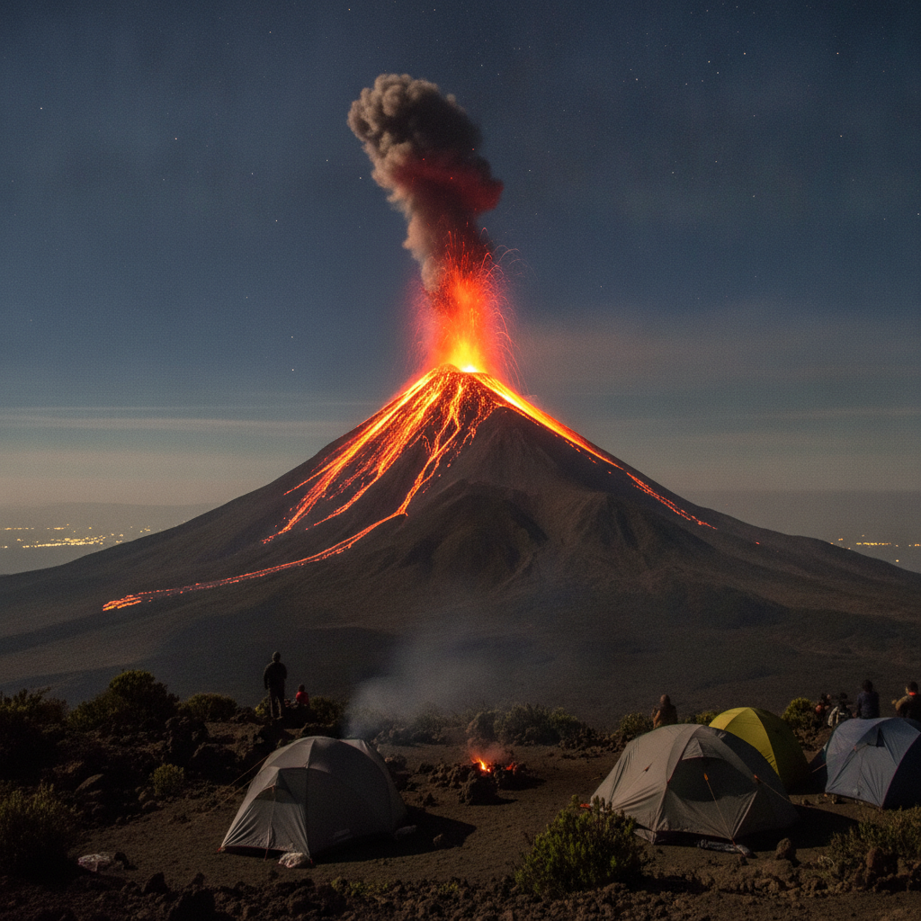
The twin volcanoes of Acatenango and Fuego above Antigua offer one of the most dramatic trekking experiences in Central America. Acatenango at 3,976 meters is climbed on a steep two-day overnight expedition; the high camp at 3,700 meters faces directly toward Fuego, which erupts with visible lava explosions multiple times per hour from the adjacent cone. The combination of the physical challenge of the ascent, the cold highland camp, and the nighttime pyrotechnic display of an active volcano makes the Acatenango overnight the most memorable single experience available from Antigua.
- 1
The Acatenango Overnight: Ascent and Camp Strategy
The Acatenango trail begins at the village of La Soledad, forty-five minutes from Antigua by shuttle, and climbs steeply through agricultural land, then pine forest, then sparse highland vegetation to the high camp at approximately 3,700 meters. The ascent takes four to six hours depending on pace and acclimatization; most hikers from Antigua have not had time to acclimatize to altitude and the final section through the loose volcanic scree is genuinely difficult. The high camp is cold, with temperatures dropping to zero degrees Celsius or below at night regardless of season. Sleeping bag rental is available from the tour operators in Antigua; down-rated to -10 degrees is appropriate. The camp faces directly across the saddle toward Fuego, and the eruptions visible from sunset through the night are the primary reason for the overnight format.
- 2
Fuego Eruptions: The Science of an Active Stratovolcano
Volcan de Fuego is one of the most persistently active volcanoes in the Western Hemisphere. Its activity follows cycles of lava effusion, explosive Strombolian eruptions producing ash columns and incandescent bombs, and occasional paroxysmal events producing large pyroclastic flows. The June 2018 eruption was the most deadly in Guatemala in more than a century, killing at least 165 people in the communities on the volcano's southern flank. The eruption overwhelmed evacuation systems and the volcanic monitoring network was criticized for inadequate warning. Access to the Fuego flanks and to the Acatenango high camp is periodically restricted by CONRED (the national disaster reduction agency) during heightened activity. Tour operators are required to monitor CONRED alerts; departures should be confirmed on the day of ascent.
- 3
Acatenango Summit and the Highland Landscape
The Acatenango summit at 3,976 meters is reached from the high camp in two to three hours of pre-dawn hiking, typically timed to arrive for sunrise. The summit crater is cold and windy, with views extending on clear days from the Pacific coast to the north of Guatemala and from the chain of all four major volcanoes visible along the highland ridge. The landscape below the summit is a panorama of the Guatemalan volcanic arc, the lake-filled calderas, and the Maya highland communities visible as settlements of red-roofed buildings. The Chichoy cloud forest in the valley below Acatenango is a nationally designated protected area visible from the summit approach. The descent back to La Soledad typically takes three to four hours and involves the knee-punishing descent through the volcanic scree that was brutal on the way up.
- 4
Alternative Volcano Experiences: Pacaya Day Hike
For visitors who cannot commit to the Acatenango overnight, Volcan Pacaya forty kilometers south of Antigua offers a two-hour day hike to an active lava field accessible by tour from Antigua. Pacaya erupted significantly in 2010, damaging the approach village of San Vicente Pacaya and raining ash on Guatemala City. The accessible lava field from the 2010 eruption is still warm in places and the hike to the active cone provides a legitimate active volcano experience without the altitude challenge or overnight cold of Acatenango. Pacaya is less dramatically visual than the Acatenango-Fuego combination but far more accessible, appropriate for older travelers or those with limited trekking fitness.
- 5
Cerro de la Cruz and Urban Volcano Views
The Cerro de la Cruz, a cross-marked hilltop northeast of Antigua reachable by a twenty-minute walk from the city center, provides the most accessible panoramic view of the city with the three volcanoes visible in alignment behind the colonial rooftops. The view is the classic Antigua photograph: the yellow and terracotta colonial buildings in the middle ground, the green volcanic cones rising behind, and Fuego's ash plume drifting to the southwest on trade winds. The walk to the cross has historically had security issues in the early morning; going with a guide or in a group is recommended for pre-dawn visits intended to catch the sunrise light. The INO (tourist police) patrols the area regularly during visitor hours.
- 6
Volcano Trekking Logistics: Guides, Gear, and Safety
All volcano treks from Antigua are organized through tour operators in the city, operating out of the many offices concentrated on the streets around the Parque Central. The Acatenango overnight costs approximately 40 to 60 USD per person including guide, transport, tent, sleeping pad, and dinner and breakfast at camp. Sleeping bag rental adds 5 to 10 USD. Independent trekking without a guide is technically possible but strongly discouraged: the trail is not well marked in the dark on the summit approach, CONRED alerts require local knowledge to interpret, and the safety management during Fuego paroxysmal events requires guide experience. Altitude sickness is a genuine risk for visitors arriving directly from low elevations; a day in Antigua before trekking at minimum is advisable.
Walk this route with audio
Stories play automatically as you reach each stop — no tapping needed.
More in Antigua Guatemala
Antigua Guatemala: Colonial Baroque, Volcano Views, and the UNESCO Historic Core
Spanish Language Schools and the Antigua Study-Travel Economy
Antigua Food Scene: Coffee, Chocolate, Pepian, and the Restaurant Economy
Colonial History: The Kingdom of Guatemala and the 1773 Earthquake
Tikal, Copan, and the Classic Maya Archaeological Circuit from Antigua