El Nido: The Bacuit Archipelago's Hidden Lagoons Accessible Only Through Rock Cracks, Barracuda Lake's 38°C Salt Water Below 28°C Freshwater & the Last Palawan Pangolin
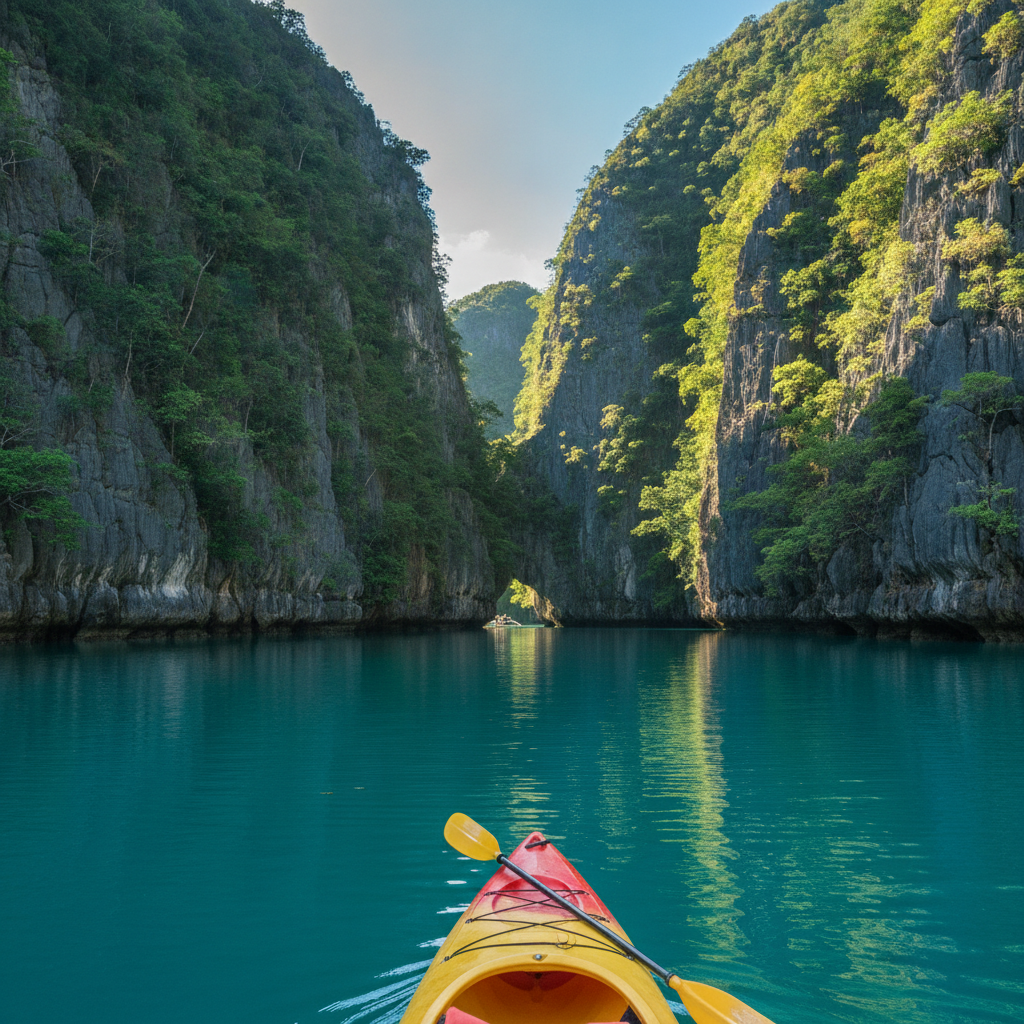
The Small Lagoon's entrance requires removing your life jacket to squeeze through a crack in the limestone—the tightest passage in a standard Philippine island-hopping tour; Tour A, B, C, and D each visiting different combinations of the 45 Bacuit Bay islands with the Cathedral Cave light shaft in Tour B and the Secret Beach hole in Tour C; Palawan's 50% remaining forest cover versus the 7% national average, protecting the Palawan peacock-pheasant and the world's smallest hoofed animal on Balabac; Barracuda Lake's halocline where 28°C freshwater sits above 38°C saltwater in a visually shimmering boundary at 10 metres; El Nido town going from 1,500 visitors in 2000 to 200,000 in 2019 via AirSWIFT; and the Big Lagoon's 1,000 daily visitors in peak season—quietly degrading the experience they came to have.
- 1
The Bacuit Archipelago – Limestone Karst & Turquoise Lagoons
The Bacuit Archipelago—45 limestone karst islands spread across the Bacuit Bay north of El Nido town (on the northern tip of Palawan province, 420 km southwest of Manila)—is the defining landscape of Palawan tourism and consistently voted the most beautiful island destination in Asia in major travel media polls. The karst geology: the vertical limestone cliffs (rising 50–300 metres directly from the sea surface) are the product of ancient coral reef material that was uplifted over millions of years, then eroded by rain and sea action into the distinctive karst tower formations seen also in Halong Bay (Vietnam), Krabi (Thailand), and Guilin (China). The specific character: El Nido's limestone towers have a characteristic shape—relatively narrow at the base (where wave action has undercut the cliff) and wider at the top (where the limestone is more resistant and the cliff overhang extends over the water), creating the silhouette that appears in virtually every El Nido photograph. The lagoons: the hidden lagoons enclosed within the limestone formations (the Big Lagoon and Small Lagoon of Miniloc Island, the Secret Lagoon of Shimizu Island, and the Cathedral Cave/Cudugman Beach combinations) are the primary island-hopping destinations—accessible only by small banca boat through narrow passages in the cliff face, or by swimming/kayaking through the cut at low water.
- 2
The Four El Nido Tours – A & B & C & D Circuits
The El Nido island-hopping tour system—officially organised by the El Nido Eco Tourism Association (ENETA) into four fixed itineraries (Tour A, B, C, and D) covering different combinations of the Bacuit Bay islands—is the primary activity structure for El Nido visitors. Tour A (the most popular—the classic El Nido tour): Miniloc Island's Big Lagoon (navigated by kayak through a narrow rock passage into a large enclosed lagoon with vertical limestone walls on all sides), Small Lagoon (similar but smaller, accessible only by swimming through a crack in the rock—the tightest passage of the standard tours, requiring removal of life jackets), Shimizu Island (the Cathedral Cave swimming hole), and 7 Commandos Beach (a 300-metre white sand beach with the most consistent coconut palm shade of the tour beaches). Tour B: Entalula Beach, Cudugman Beach, Cathedral Cave (a large sea cave with a photogenic shaft of light—the location of every El Nido tourist photograph taken before 2010), and Pinagbuyutan Island. Tour C: the outer Bacuit Bay islands—Helicopter Island (a long thin island with a shape resembling a helicopter from above), Matinloc Shrine (a religious shrine in a cave on Matinloc Island), Secret Beach (a beach accessible only through a hole in the cliff, revealed only at low tide), and Star Beach. Tour D: the Cadlao Island circuit—Cadlao Lagoon, Paradise Beach, Nature Island. The Nacpan Beach addition: some operators add the 4-km Nacpan Beach (north of El Nido town) to Tour C or D—the longest and most developed beach in the El Nido area, suitable for swimming and beginner surfing.
- 3
Palawan's Biodiversity – The Philippine's Last Ecological Frontier
Palawan province (the elongated island province of the Philippines, 450 km long and 50 km wide, stretching from the northern tip at Busuanga to the southern tip at Balabac)—is designated the 'last ecological frontier' of the Philippines: the island that has retained the most original forest cover (approximately 50% versus the national average of 7%), the most diverse endemic wildlife, and the most intact marine ecosystems in the Philippine archipelago. The Palawan endemics: Palawan has 49 endemic vertebrate species, including the Palawan pangolin (Manis culionensis—one of the world's most trafficked mammals, protected in Palawan but still subject to poaching for the Chinese traditional medicine market), the Palawan peacock-pheasant (Polyplectron napoleonis—one of the most ornate birds in Southeast Asia, with iridescent blue and green eye-spots on the tail; found only on Palawan), the Palawan hornbill (Anthracoceros marchei), and the Philippine mouse deer (Tragulus nigricans—the world's smallest hoofed animal, found only on Palawan's Balabac island). The Tubbataha Reef Natural Park (in the Sulu Sea, 150 km southeast of Puerto Princesa—accessible by liveaboard from Puerto Princesa only): a UNESCO World Heritage Site and one of the three most biodiverse reef systems in the world; access is only permitted for 3 months per year (mid-March to mid-June) due to weather and conservation constraints.
- 4
El Nido Town – The Village That Became a Destination
El Nido town (the municipality on Palawan's northern tip—a community of approximately 35,000 people on a narrow coastal strip between the Bacuit Bay and the limestone hills behind)—has transformed from a remote fishing village into one of the Philippines' most commercially developed tourism destinations in the space of 20 years. The transformation timeline: in 2000, El Nido had no paved roads, unreliable electricity (a small generator serving the town centre), no ATMs (the nearest were in Puerto Princesa, a 6-hour bus ride away), and approximately 1,500 visitors per year; by 2019, the town had over 200,000 international visitors annually, 500+ accommodation establishments, all-day electricity, ATMs, and direct flights from Manila (1.5 hours) and Manila to El Nido (via Lio Airport, the private airport operated by the Ayala Corporation's Ten Knots resort development). The Ten Knots Development: the Ayala Corporation (the oldest and most respected Philippine conglomerate) developed the El Nido Resorts brand in the early 1990s—first at Miniloc Island, then Lagen Island, Apulit Island, and the Lio Tourism Estate (a master-planned tourism estate north of El Nido town with boutique hotels, restaurants, and the Lio Airport). The physical limits of El Nido town: the town occupies a very narrow coastal strip—the main street (Hama Street and Serena Street) runs for approximately 1 km parallel to the beach; the accommodation is concentrated in a 500-metre radius of the main road.
- 5
El Nido Diving – The Barracuda Lake & Deep Sites
The diving around El Nido—distinct from the snorkelling-focused island-hopping tours—provides access to a series of sites with excellent marine biodiversity and specific features unavailable elsewhere in the Philippines. Barracuda Lake (on Coron Island, the southern end of the Calamian archipelago—2 hours by speedboat northwest of El Nido): a lake of extraordinary character, reached by a 5-minute scramble over a limestone cliff—the water is simultaneously fresh and salt (the lake is fed by submarine seawater vents and by rainfall runoff), creating a visible halocline (a sharp boundary between the denser salt water and the lighter fresh water that appears as a shimmering refractive layer at approximately 10 metres depth); the temperature gradient within the halocline is as striking as the visual—from 28°C in the fresh water above to 38°C in the salt water below (a thermally inverted lake). The El Nido dive sites: the walls and reef systems around the Bacuit Bay islands—the Dilumacad (Helicopter Island) wall, the north face of Matinloc Island, and the Cadlao Island reef—provide coral reef diving at 10–30 metres depth with good fish diversity (Napoleon wrasse, sweetlips, sea turtles, and occasional leopard sharks). The Coron wrecks (the most significant dive destination accessible from El Nido for those with extra time): 12 Japanese WWII supply ships sunk in a single US air raid on 24 September 1944, now colonised by coral and marine life at 10–40 metres depth in Busuanga Bay—among the finest wreck diving in Southeast Asia.
- 6
Practical El Nido – Getting There, Money & Responsible Tourism
Getting to El Nido: the most practical options are by air (from Manila to El Nido via AirSWIFT, the only airline operating the route—approximately 1.5 hours, with limited daily flights; or Manila to Puerto Princesa—1 hour, then 5.5-hour van transfer to El Nido) or by ferry (from Coron—3–4 hours by fast ferry; or the longer option from Batangas port near Manila—14–18 hours by RORO ferry). Money: El Nido has ATMs (at the BDO and Metrobank machines in the town centre—reliable but often empty; withdrawing cash in Puerto Princesa before the journey is recommended). The tour pricing: the ENETA-fixed tour prices (as of 2023, approximately PHP 1,200–1,800/person for shared tours A/B/C/D, excluding entrance fees) apply to all shared bangca tour operators; private tours cost PHP 4,000–8,000 for the boat. The El Nido entrance fees: the Bacuit Bay Environmental User Fee (approximately PHP 200/person/day, valid for the day's tours)—charged upon entry to each island-hopping tour. Responsible tourism: El Nido has experienced rapid development that has strained infrastructure (water supply, waste disposal, beach erosion); responsible choices include avoiding single-use plastic (the island's waste management is inadequate for the visitor volume), respecting no-entry zones (certain lagoons have seasonal closures for reef recovery), and choosing accommodation with documented sustainability practices (the DENR has published guidelines but enforcement is variable). The overcrowding signal: the Big Lagoon and Small Lagoon of Miniloc Island receive approximately 1,000 visitors per day in peak season—a volume that is visibly degrading the reef and creating a notably un-'hidden lagoon' experience.