Gaborone Final Legacy: Okavango Flood Cycle, Safari Photography, Francistown, A1 Highway, Kalahari Stars, and Complete Reference
Gaborone closing routes: the Okavango annual flooding cycle, Botswana safari photography conditions, Francistown and the Tati gold rush, the A1 highway spine of Botswana, the Kalahari night sky, and the six-route complete Botswana travel reference.
- 1
The Botswana Delta Flooding Cycle - The Annual Pulse of Life
The Okavango Delta flooding cycle: the most dramatic seasonal ecological transformation in southern Africa. The Okavango River rises in the Angolan highlands in the December-February rainy season; the flood wave travels 1,000 km downstream and arrives in the Okavango Delta in April-June (3-4 months after the Angolan rains). The delta swells from approximately 6,000 sq km (dry season minimum) to approximately 20,000 sq km (wet season maximum): the difference equivalent to the entire land area of Slovenia. The pulse of life: the arrival of the flood triggers a mass movement of wildlife toward the water (May-August), concentrating animals on the islands and at the water channels, producing the finest wildlife concentrations of the year. The receding flood (August-October): the water withdraws from the outlying areas and the wildlife follows; the dense, dry-season concentrations at the permanent water holes of the Moremi and Chobe are the result of this process. The Okavango has no outlet: all the water evaporates or is transpired by the vegetation; none reaches the sea.
- 2
Botswana Photography - The Finest Safari Photography Conditions in Africa
Botswana is widely considered by wildlife photographers to offer the finest combination of wildlife density, photographic access, and light conditions in Africa. The reasons: the luxury fly-in camps position vehicles at the most productive wildlife locations; the low visitor numbers mean minimal competition for position; the open savanna and floodplain habitats of the Okavango and Chobe offer clear sightlines; and the high concentration of predators (lion, leopard, cheetah, wild dog) means action encounters are relatively frequent. The golden hour light (the first and last hours of daylight): in the flat landscapes of the Okavango and Chobe, the low-angle golden light of dawn and dusk falls directly on wildlife subjects from the vehicle level, creating the iconic amber-toned African wildlife photographs. The primary photographic locations: Chief Island water hole (Moremi), the Chobe riverfront (elephant close range from boat), the Savute Channel lion (Chobe), and the Khwai community area wild dog dens.
- 3
Francistown - The Second City and the Zimbabwe Border
Francistown: the second city of Botswana (population approximately 100,000), approximately 450 km north of Gaborone on the A1 highway, 90 km from the Zimbabwe border crossing at Plumtree. Francistown is the primary commercial and transport hub of northern Botswana. The Supa Ngwao Museum (in Francistown): the primary museum of northern Botswana history, with exhibits on the Tati gold rush (gold was discovered near Francistown in 1867, making this one of the earliest gold rushes in southern Africa). The Tati Gold Mine area (the original concession that gave Francistown its commercial importance): now exhausted, the mine history is the primary heritage interest of the town. Francistown is primarily a transit point between Gaborone and the Chobe-Okavango tourist circuit. The Ramokgwebana border crossing (between Botswana and Zimbabwe): the primary border crossing between Botswana and Zimbabwe for overland vehicles traveling to or from Victoria Falls.
- 4
The A1 Highway - The Spine of Botswana from Gaborone to Kasane
The A1 highway: the primary paved road of Botswana, running approximately 950 km from Lobatse (near the South Africa border) through Gaborone, Francistown, Nata, and Kasane to the Zimbabwe border (the Kazungula crossing). The road through Botswana is one of the most atmospheric long-distance drives in southern Africa: the flat acacia and mopane savanna, the enormous skies, the occasional elephant crossing the road near Kasane, and the roadside baobab trees. The elephant warning signs: the A1 highway through the northern section (near Kasane) passes through wildlife corridors and elephants frequently cross the road at night; driving after dark is not recommended. The petrol station infrastructure: petrol is available at regular intervals along the A1 (unlike in some African countries where fuel is unreliable); BP and Engen are the primary brands. The speed limit: 120 km/h on the A1 outside towns; traffic police radar speed traps are common on this route.
- 5
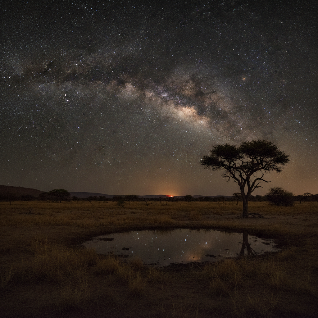
The Botswana Night Sky and the Kalahari Stars
The Botswana night sky: the Central Kalahari and the areas surrounding the Okavango and Makgadikgadi have some of the darkest skies in southern Africa (second only to the NamibRand in Namibia for darkness). The Milky Way visibility: in the CKGR and the remote Makgadikgadi, the Milky Way is visible on cloudless nights as a bright white band spanning the entire sky from horizon to horizon. The galactic center (the most brilliant part of the Milky Way in the direction of Sagittarius): visible in the June-August winter sky directly overhead at approximately midnight in Botswana. The Southern Cross (Crux australis): the primary navigational constellation of the southern hemisphere, visible from Botswana throughout the year. The Magellanic Clouds (the two dwarf satellite galaxies of the Milky Way visible to the naked eye in the southern sky): visible from dark Botswana sky sites as fuzzy patches of light. Star photography in the Kalahari: a tripod, wide-angle lens (14-24mm), and ISO 3200-6400 for 20-30 second exposures gives the full Milky Way arch.
- 6
Gaborone Six-Route Final Legacy - The Complete Botswana Reference
Gaborone six-route complete final. Route 1: Botswana economic miracle (from poorest to upper-middle income in 50 years through diamond management), Debswana diamond partnership (Jwaneng richest by value, Orapa largest by area), Seretse Khama and Ruth Williams, Okavango Delta introduction, Central Kalahari San, practical guide. Route 2: Chobe (120,000 elephants), Moremi Game Reserve, Tswana kgotla democratic institution, Tsodilo Hills UNESCO (4,500 San rock paintings), Makgadikgadi salt pans (world largest), zebra migration. Route 3: military anti-poaching, San CKGR land rights victory, African wild dog (most endangered large carnivore), Tswana traditional food and Kuru Art Project, 58-year democracy (broken in 2024). Route 4: pula currency (named for rain), Maun safari hub and light aircraft, Linyanti marshes hidden wildlife, Khama Rhino Sanctuary community conservation, Botswana 600 bird species. Route 5: Kalahari lion and Deception Valley, southern Africa overland route, Gaborone lifestyle, free education and Masa HIV program, Botswana vs Rwanda model. Route 6 (this route): Okavango flooding cycle, safari photography conditions, Francistown and the Tati gold rush, the A1 highway drive, the Kalahari night sky. Botswana final: the country with the most successful development story in Africa; where the ancient San hunt alongside luxury safari camps; where 130,000 elephants share the land with 2.6 million people; and where the stars of the Kalahari blaze in the darkest sky south of the Sahara.