The 250,000-Year-Old Cave That Drained Itself Empty, the 1948 Massacre That Killed 10% of the Island's Population & the Only Road in Korea That Crosses 1,950 Metres
The Manjanggul lava tube's self-draining formation process over 250,000 years; the 7.6-metre lava column as the largest in any accessible lava tube worldwide; the Jeju April 3rd Incident's 14,000–30,000 deaths unacknowledged until 2003; the 820-year-old cypress trees in Bijarim Forest; the Gwaneumsa Trail's ridge walking as the most dramatic Hallasan ascent; and the 3-day east-west-south itinerary with haenyeo-caught abalone congee at the base of the Ilchulbong.
- 1
Seongsan Ilchulbong – The Sunrise Peak
Seongsan Ilchulbong (성산일출봉—the 182-metre tuff cone at the northeastern tip of Jeju Island, listed as a UNESCO World Natural Heritage Site): the most-visited single natural site on Jeju and the landmark most associated with the island internationally. The geology (the tuff cone was formed approximately 100,000 years ago when magma erupted through the shallow sea floor and the steam-water-ash mixture solidified into the rough grey tuff rock): the 600-metre wide crater at the summit (the 99 rock spires around the crater rim and the grass-covered crater bowl): the most dramatic volcanic crater rim in Korea. The sunrise (the name 'Ilchulbong' means 'sunrise peak'—the cliff-facing sunrise from the crater rim is one of the 4 'Yeongju Ten Scenes' (영주십경—the traditional list of the 10 most beautiful Jeju landscapes): the practical sunrise visit (arrive at Seongsan town at 05:30 in summer (June–August sunrise at 05:30–06:00) or 06:45 in winter (December–January sunrise at 07:25–07:35); the gate opens 1 hour before sunrise; the 30-minute ascent reaches the crater rim with 15 minutes to spare). The Seongsan village (the small fishing village at the base of the tuff cone—the village square with the haenyeo performance (the daily haenyeo diving demonstration in the sea directly below the Ilchulbong cliff face—the haenyeo dive in a small cove below the tuff cone cliffs at designated performance times (09:20, 11:20, 13:20, 14:20) from March to November): the most accessible live haenyeo demonstration in Jeju.
- 2
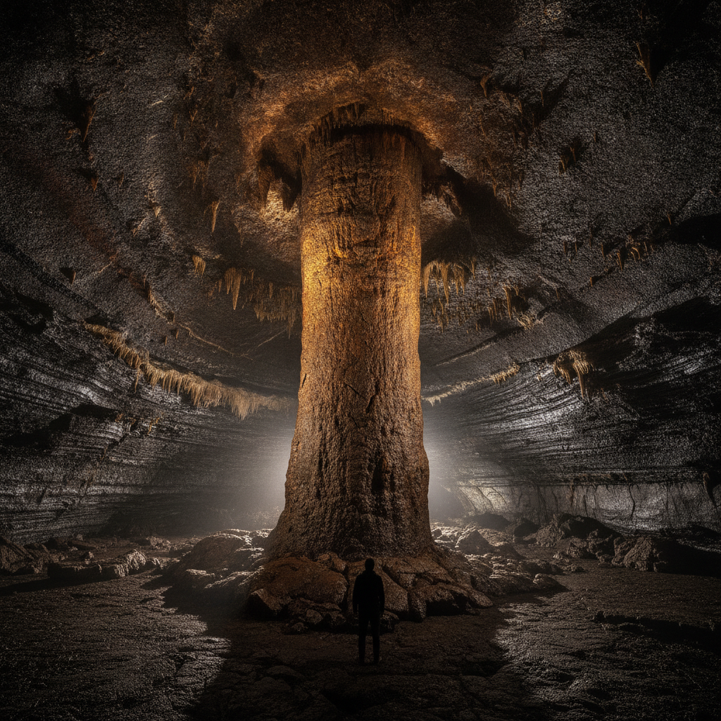
Manjanggul Cave & The Lava Tube System
The Manjanggul Lava Tube (만장굴—the most accessible section of the Geomunoreum Lava Tube System, the UNESCO World Natural Heritage component listed for the world's most significant exposed lava tube cave system): the cave that brings the Jeju volcanic geology from the surface down into the island's interior. The Manjanggul system (the complete Manjanggul cave system extends 7.4 km—the longest accessible lava tube cave system in the world when measured by the continuous connected passages; the caves were formed approximately 250,000 years ago when a lava flow from the Geomunoreum oreum (the source vent, 13 km north of the cave) drained through its interior while the exterior cooled and hardened, leaving a hollow tube): the secondary cave formations (the cave coral (the white calcium carbonate formations on the cave walls produced by water percolating through the overlying soil), the lava stalactites (the drip formations from the cave ceiling produced when the last lava flow cooled), and the lava raft formations (the flat slabs of lava that floated on the last draining lava flow and settled on the cave floor)): the most diverse secondary formation set of any lava tube cave in the world. The 7.6-metre lava column (the single lava column at the far end of the accessible 1 km section—the largest lava column in any accessible lava tube cave in the world; the column was formed when the last drained lava flow left a column of solidified lava connecting the floor to the ceiling): the primary natural attraction at the end of the illuminated cave walk.
- 3
Hallim Park & Jeju's Western Coast
The Jeju western coast (the least visited coastal zone of Jeju for international tourists but the most varied in terms of the combination of volcanic geology, beach scenery, and cultural heritage): the part of the island that rewards a visitor who has a rental car and wants to escape the eastern tourist circuit. Hallim Park (한림공원—the private botanical and cultural park in Hallim town on the western coast, opened 1971): the park that provides the most complete single-site introduction to Jeju's natural diversity (the subtropical plant collection, the 2 lava tube caves accessible within the park (Hyeopjae Cave and Ssangyong Cave—the lava tube with the most calcite stalactite formations on Jeju due to the overlying limestone layer), the bonsai garden (2,000+ bonsai trees—the largest bonsai collection in Korea), and the traditional Jeju folk village reconstruction. The Hyeopjae Beach (협재 해수욕장—the beach immediately north of Hallim Park—the most photographed beach on Jeju (the white sand, the shallow turquoise water, and the silhouette of Biyangdo Island (the small volcanic island 500 metres offshore whose cone rises against the sunset sky)): the most compositionally perfect Jeju beach photograph. The Biyangdo Island (the small volcanic island 500 metres off Hyeopjae Beach—accessible by a 15-minute ferry from Hallim Port (departures at 09:00, 12:00, 15:00): the island with 2 small oreums and the quietest day hike accessible from Jeju's west coast). The Jeju Olleroad (the coastal walking path network—the 26-section Jeju Olle Trail (437 km total) that circumnavigates the entire island along the coastline).
- 4
Jeju's Japanese Colonial & Modern History
The Jeju history beyond the natural landscape (the island's political and military history that shaped the landscape in ways a visitor encounters without necessarily recognizing): the colonial and modern history that is the least-documented dimension of Jeju for international visitors. The Japanese colonial infrastructure (the Japanese colonial administration of Jeju (1910–1945) built the most extensive military fortification of any Korean island—the 17 military tunnels (진지동굴, jinjidongul) dug by forced labor into the Jeju basalt cliffs in 1945 as kamikaze boat hideouts and invasion defense positions): the most accessible colonial tunnel (the Seodgwipo Bunker (the Alddreu Air Force Base Bunker)—the former Japanese military tunnel complex south of Seogwipo that is now the venue for the Bunker de Lumières immersive digital art installation). The Jeju April 3rd Incident (제주 4·3 사건—the anti-communist suppression campaign of 1948–1954 in which the South Korean government and the US military government launched a military campaign against suspected communist sympathizers on Jeju): the most traumatic event in Jeju's modern history—estimated 14,000–30,000 Jeju residents killed out of a population of 300,000 (5–10% of the island's population): the massacre was not publicly acknowledged by the South Korean government until 2003. The Jeju 4·3 Peace Park and Memorial Hall (the memorial park opened 2008 in Bongae-dong, Jeju City): the most important historical site in Jeju after the natural landmarks and the one most necessary for understanding why Jeju's relationship with the South Korean state has been complicated.
- 5
Hallasan Trail Guide – Which Route to Take
The complete Hallasan hiking guide (the practical decision framework for the visitor choosing between the 5 official Hallasan trails and planning the timing and logistics of the most rewarding mountain day in South Korea): the route selection guide. The 2 summit trails (the only routes that reach the Baengnokdam crater lake): Seongpanak Trail (9.6 km, 4.5h ascent, 3.5h descent—the longest and most gradual; the trail starts at the Seongpanak parking area on the 5.16 Road (the main cross-island highway) at 750m elevation; the trail passes through dense temperate deciduous forest before emerging above the treeline at 1,600m; the crater lake view from the rim is directly east-facing (best light in the morning); the trail closes when snow makes it unsafe—typically November to late April); Gwaneumsa Trail (8.7 km, 5h ascent, 4h descent—the steepest and most exposed; starts from Gwaneumsa Valley on the north side at 620m elevation; the trail climbs through the Tam-na Valley with views of the Witsaeorum peak before the final ridge to the summit): the trail that provides the most dramatic ridge walking and the best view of the crater rim. The 3 non-summit trails: Eorimok Trail (5.8 km to 1,700m—the best winter snow trail due to the sheltered forest walking and the dense snow-covered forest scenery at 1,700m); Yeongsil Trail (5.8 km to 1,700m—the best single-day spring wildflower trail due to the Gureum Garden (the alpine meadow below the summit at 1,700m where the azalea blooms in May)); Donnaeko Trail (9.1 km to 1,600m—the least used trail, providing the most solitary hiking experience on the mountain).
- 6
Jeju 3-Day Itinerary – East, West & Central
The complete Jeju 3-day first visit itinerary (the schedule that divides the island into the logical geographic zones—the eastern circuit on Day 1 (the UNESCO sites), the central/western circuit on Day 2 (beaches and oreums), and the southern Seogwipo circuit on Day 3 (cliffs and waterfalls)): Day 1 (Eastern Jeju): pick up rental car at Jeju Airport → Manjanggul Lava Tube (the UNESCO cave—arrive at 09:00 when the cave opens, before tour groups; 1.5 hours for the 1 km cave walk and return) → Bijarim Forest (the protected cypress forest in Gujwa-eup—the largest natural cypress forest in Korea, 2,800 trees up to 820 years old, accessible by a 2-km forest walk) → Seongsan Ilchulbong (the UNESCO tuff cone—the afternoon arrival avoids the sunrise crowds; climb to the crater rim takes 30 minutes; 1.5 hours on-site): Day 1 lunch: the Seongsan haenyeo restaurant cluster (the seafood restaurants in the village at the base of the Ilchulbong where the haenyeo dive happens—order the haenyeo-caught abalone congee (전복죽, jeonbok-juk)). Day 2 (Central & Western Jeju): Saebyeol Oreum (the western grassland oreum—45-minute round trip; the flat western landscape views) → Hyeopjae Beach (morning swim + Biyangdo Island backdrop photography) → Hallim Park (2 hours for the full circuit including the lava caves and bonsai garden) → Aewol coastal road drive at sunset. Day 3 (Southern Jeju / Seogwipo): Hallasan Eorimok Trail (the non-summit trail to 1,700m—4 hours round trip, no special permit required, no closure risk): → Jeongbang Waterfall → Cheonjiyeon Waterfall → Oedolgae Rock → Seogwipo black pork dinner.