Kauai: Na Pali Coast Sea Cliffs and Kalalau Trail (18km hiking permit), Waimea Canyon (Grand Canyon of the Pacific, 1097m deep), Hanalei Bay and Taro Valley (Jurassic Park locations, Tunnels Beach snorkeling), Poipu South Shore (Hawaiian monk seals, bodysurfing, Koloa rum distillery), and Film History (Raiders of the Lost Ark, Pirates of Caribbean, Jurassic Park) with Practical Guide
Kauai highlights: Garden Isle overview (oldest main Hawaiian island 5.1M years, wettest spot on earth at Waialeale, resisted Kamehameha conquest), Na Pali Coast (27km sea cliffs, Kalalau Trail permit hiking, summer catamaran tours, helicopter flights), Waimea Canyon (1,097m deep, Grand Canyon comparison, Kokee highlands), Hanalei Bay (most beautiful bay in Hawaii, taro valley wildlife refuge, Jurassic Park location), Poipu sunny south shore (monk seals, Koloa sugar plantation 1835, rum distillery), and film locations (Raiders of the Lost Ark, Pirates Caribbean) with Lihue Airport practical guide.
- 1
Kauai - the Garden Isle, the Oldest Hawaiian Island
Kauai (the Garden Isle, population approximately 73,000): the northernmost and oldest main Hawaiian island, at 5.1 million years old (Oahu is 3.7 million years old, Maui is 1.3 million years old, and the Big Island is still forming). Because Kauai formed earlier over the Pacific Plate hotspot and has been moving away from the hotspot longer, it is the most deeply eroded of the main islands: the interior is dominated by the immense Waimea Canyon and the rugged mountains of the island interior, with no true flat plateau like Maui. Kauai geography: the center of the island is dominated by Mount Waialeale (1,569 m), one of the wettest spots on earth, receiving approximately 11,430 mm of rain per year (one of the two or three highest annual rainfall totals recorded anywhere on earth). The island is divided by this central wet zone into distinct dry south and west sides (the Poipu and Waimea coasts) and wet north and east sides (the Hanalei and Kilauea coasts). The Na Pali Coast (the 27 km stretch of fluted green sea cliffs on the northwest coast of Kauai, between the end of the road at Ke-e Beach and the valley of Polihale): the most dramatic and inaccessible coastline in Hawaii. Kauai is unique among the main Hawaiian islands in having successfully resisted the control of Kamehameha I (Kauai Chief Kaumualii negotiated a voluntary cession in 1810 rather than submit to military conquest, making Kauai the last island to join the Hawaiian kingdom).
- 2
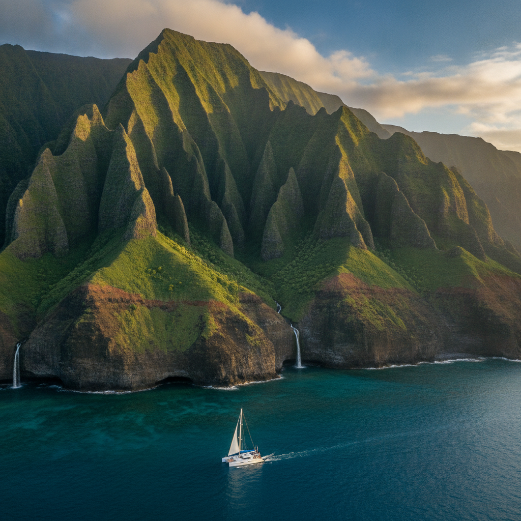
Na Pali Coast - the Most Dramatic Coastline in the Pacific
The Na Pali Coast State Wilderness Park (on the northwest coast of Kauai, between Ke-e Beach and Polihale State Park): 6,175 acres of fluted green sea cliffs (na pali means the cliffs in Hawaiian) rising 900-1,200 m directly from the Pacific Ocean, with no road access along the entire 27 km stretch. The Kalalau Trail (the 18 km trail along the Na Pali Coast, from the Ke-e Beach trailhead to the Kalalau Valley): the most famous hiking trail in Hawaii, classified as strenuous to extreme and requiring a state permit for camping. The trail descends and climbs over five major valleys (Hanakapi-ai, Hoolulu, Waiahuakua, Hanakoa, Kalalau), with the most frequented section being the 3.2 km to Hanakapi-ai Beach and the Hanakapi-ai Falls (4.6 km round-trip from the trailhead). The Kalalau Valley (at the end of the trail, 18 km from the trailhead): the largest of the Na Pali valleys, with the Kalalau River, the bamboo forest, the wild guava trees, and the most remote camping in Hawaii (maximum 5-night permit, boat access also available). Na Pali by boat: the summer season (May-September, when the seas on the Na Pali coast are calm): catamaran and raft tours from Port Allen or Hanalei Bay provide the closest approach to the sea caves and waterfalls (the Nualolo Kai snorkeling area within the Na Pali Coast Marine Reserve). Na Pali by helicopter: year-round helicopter flights from Lihue Airport provide the complete aerial perspective of the sea cliffs, valleys, and the Kalalau Valley floor.
- 3
Waimea Canyon - the Grand Canyon of the Pacific
Waimea Canyon State Park (on the west side of Kauai, approximately 30 km from Lihue): the canyon carved by the Waimea River and its tributaries into the ancient volcanic rock of the Kauai interior. Waimea Canyon dimensions: approximately 16 km long, 1.6 km wide, and 1,097 m deep. The canyon walls expose multiple layers of volcanic basalt in red, orange, brown, and green tones, leading to the comparison with the Grand Canyon. The geology of Waimea Canyon: unlike the Grand Canyon (carved by the Colorado River through horizontal sedimentary layers), Waimea Canyon was carved into the basalt of the Kauai shield volcano; the canyon floor follows the Waimea River, which drains the wet interior of Kauai. The canyon was formed partly by a section of the volcano collapsing into the caldera, creating a topographic low that captured the river drainage. The Waimea Canyon Lookout (at 1,060 m elevation, on the Waimea Canyon Drive): the primary viewpoint over the main canyon, with views of the 270 m Waipo-o Falls across the canyon. The Kokee State Park (above the Waimea Canyon, at 1,100-1,200 m elevation): the cool highland plateau with the Kokee Museum, extensive hiking trail network (45 km of trails), and the Kokee Lodge restaurant. The Kalalau Valley Lookout (at the end of the Kokee Road, at 1,219 m elevation): the most dramatic viewpoint in Kauai, looking down 1,200 m to the Kalalau Valley and the Na Pali Coast far below, with the Pacific Ocean visible beyond.
- 4
Hanalei Bay and the North Shore - Jurassic Park and Taro Valley
Hanalei Bay (on the north shore of Kauai, approximately 50 km north of Lihue): the most beautiful bay in Hawaii, a 3 km crescent of beach framed by the fluted green mountains of the Hanalei Valley and the Namolokama Ridge. Hanalei town (at the back of the bay): the most charming small town in Hawaii, with a population of approximately 500, wooden storefronts housing surf shops, art galleries, and restaurants, and the Waioli Mission House (built 1836, the best preserved mission house in Hawaii). The Hanalei National Wildlife Refuge (the taro paddies of the Hanalei Valley, visible from the Hanalei Valley Lookout on the highway above town): the largest taro growing area in Hawaii, providing most of the poi (the pounded taro paste that is the traditional Hawaiian staple food) consumed in the state. The taro is grown in the traditional Hawaiian lo-i (flooded paddy) system in the Hanalei River floodplain, managed by Native Hawaiian families under the Office of Hawaiian Affairs. Film locations on the north shore: the Limahuli Valley (behind Haena State Park, at the end of the north shore road): the Jurassic Park (1993) opening shots of the dinosaur island. The Hanalei pier (the wooden pier in the Hanalei Bay): featured in the film The Descendants (2011). Tunnels Beach (Makua Beach, at Haena): the best shore snorkeling on Kauai, with the large reef extending 0.6 km offshore and the frequent presence of green sea turtles and reef sharks. Ke-e Beach (the end of the north shore road, the start of the Na Pali Kalalau Trail): the most dramatic beach setting in Kauai.
- 5
Poipu Beach and South Kauai - Sun, Snorkeling and Monk Seals
Poipu (the primary resort and beach area on the south coast of Kauai, approximately 18 km from Lihue): the sunniest part of Kauai (the south shore receives approximately 300 days of sunshine per year, compared to the wet north shore). Poipu Beach Park (the family beach and snorkeling beach at the Poipu resort area): the beach at Poipu has two distinct sections: the east beach (calm, protected, with a shallow sand bar, ideal for children and families) and the west beach (more exposed, with reef snorkeling along the Kukuiula side). Monk seal sightings: the Hawaiian monk seal (Neomonachus schauinslandi, critically endangered, with approximately 1,400 individuals remaining, the only native marine mammal in Hawaii): the seals frequently haul out to rest on Poipu Beach and other south shore beaches; the NOAA marine mammal handlers place rope perimeters around resting seals to prevent disturbance. Poipu Beach and the Brenneckes Beach bodysurfing (immediately east of the park): the consistent shore break at Brenneckes is the best bodysurfing spot on Kauai. Koloa (the historic plantation town 3 km inland from Poipu): the site of the first successful sugar plantation in Hawaii (established 1835 by Ladd and Company). The Koloa Rum Company (at the Old Koloa Mill site): the primary rum distillery on Kauai, producing Hawaii-grown sugarcane rum. Spouting Horn (at Lawai, west of Poipu): the natural lava tube blowhole that shoots seawater 6-12 m into the air with each wave, accompanied by a distinctive deep moaning sound.
- 6
Kauai Film History and Practical Guide
Kauai film locations and practical guide: Kauai is the most film-used Hawaiian island, with the lush green valleys and sea cliffs providing locations for dozens of major productions. Primary Kauai film locations: the Jurassic Park franchise (1993-present): the Manawaiopuna Falls (the Helicopter Falls from the 1993 opening sequence, accessible only by helicopter); the Limahuli Valley (Haena); the Allerton Garden (Lawai Valley, south shore). Raiders of the Lost Ark (1981): the opening sequence (Indiana Jones fleeing from the boulder and the tribe in the South American jungle) was filmed in the Huleia National Wildlife Refuge (the stream valley south of Lihue, visible from the Menehune Fish Pond overlook). Pirates of the Caribbean On Stranger Tides (2011): the waterfall chase scenes at the Wailua Falls (an 27 m double waterfall on the east coast of Kauai, visible from the road). The Thornbirds (1983 miniseries): Kauai locations used for the Australian sheep station. Kauai practical guide: Lihue Airport (LIH): interisland flights from Honolulu (30 min) and Maui (30 min), with some direct mainland flights (Los Angeles, San Francisco, Seattle, San Jose, Denver). Rental cars are essential; no real public transit. The road on the north shore ends at the Haena State Park parking area (reservations required to access the park); vehicles cannot proceed to the Ke-e Beach trailhead without a reservation. The road on the west side ends at Polihale State Park (the long, remote beach at the base of the Na Pali cliffs). The population center is Lihue-Kapaa on the east coast.