Iceland's South Coast — Skógafoss, Seljalandsfoss, the Black Sand Beach & the Eyjafjallajökull Glacier
The South Coast of Iceland between Reykjavik and the Vatnajökull glacier contains the most varied and dramatic scenery in Iceland — the waterfalls, the black sand beaches, the glacier tongues, and the active volcanic systems all accessible in a single day from Reykjavik.
- 1
Seljalandsfoss — the Waterfall You Can Walk Behind
Seljalandsfoss (the waterfall 120km east of Reykjavik on Route 1, the single most Instagram-published Icelandic location — the 65m waterfall dropping from the plateau cliff edge with a cave accessible behind the falls, the path around the back of the falls allowing the visitor to stand behind the water curtain and view the Icelandic coastal plain from inside the cascade, the path open May-October — the path closes in winter when the spray freezes to form black ice on the rock, the access free year-round, the parking fee €750 ISK at the car park): the walk behind the falls (the 200m path following the cliff base, the rock overhang providing protection from the direct spray for the first 100m, the final section directly behind the falls requiring a rain jacket or waterproof clothing regardless of the weather — the spray soaking the unprepared visitor in 2 minutes, the view from behind the falls the unique perspective of the landscape through the water curtain, the photography from inside looking out the most distinctive Icelandic waterfall photograph), and Gljúfrabúi (the hidden waterfall 500m north of Seljalandsfoss, the falls concealed inside a narrow gorge accessible through a hip-height stream — the boots or the waterproof trousers essential, the falls 40m tall in the hidden chamber, the photographic reward for getting wet the most dramatic interior waterfall in southern Iceland, free, always accessible, visited by 5 percent of the Seljalandsfoss visitors despite being 500m away).
- 2
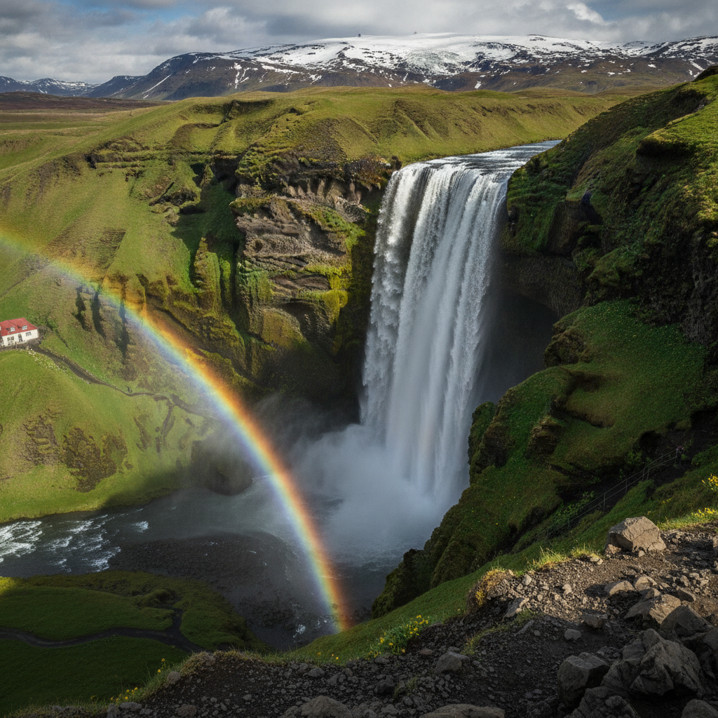
Skógafoss — the Classic Icelandic Waterfall
Skógafoss (the waterfall 145km from Reykjavik on Route 1, the most classically beautiful waterfall in Iceland — 62m tall, 25m wide, the falls dropping from the Eyjafjallajökull plateau cliff into the Skóga River valley, the rainbow in the spray visible almost every day from the concrete viewing platform at the base, the staircase on the east side of the falls climbing 527 steps to the plateau level — the view from the top the best accessible panorama of the Icelandic South Coast, the black volcanic sand beach visible to the south at the river mouth): the Skógar Museum (Skógarsafn, the open-air folk museum adjacent to the waterfall, the largest rural folk museum in Iceland, the collection of 15,000 objects from the pre-industrial Icelandic farm — the fishing boats, the peat-cutting tools, the household objects, the turf farmhouses reconstructed on the museum site, the most complete surviving example of the traditional Icelandic sod-and-stone farm construction in the museum garden, €14 adults, daily 10am-5pm), the Fimmvörðuháls pass (the mountain pass behind Skógafoss connecting the south coast to Þórsmörk — the most famous hiking route in Iceland, the 25km trail from Skógar to Þórsmörk crossing the plateau between the Eyjafjallajökull and Mýrdalsjökull glaciers, the trail passing the 2010 eruption craters of Eyjafjallajökull directly — the trail the most dramatic volcanic landscape walk in Europe, 8-10 hours one-way, mountain huts available at Baldvinsskáli) and the Eyjafjallajökull eruption context (the 2010 eruption beneath the glacier — the heat from the sub-glacial eruption melting the ice and generating the volcanic ash plume that closed European airspace for 6 days, the largest disruption to European aviation in history, the eruption visible from the Skógar valley during the May 2010 activity).
- 3
Reynisfjara — the Black Sand Beach
Reynisfjara (the black volcanic sand beach on the South Coast 178km from Reykjavik, the most visited beach in Iceland and one of the most dangerous — the sneaker waves approaching from the North Atlantic without warning, the beach's 7 fatalities since 2010 making the safety warnings at the parking area the most prominent in Iceland — the correct protocol is to never turn your back to the sea and to stay 30m back from the water line): the beach (the jet-black volcanic basalt sand covering the beach, the sand composed of the eroded basalt rock — the dark mineral magnetite and the black pyroxene creating the colour, the sand cooling rapidly as the wave recedes, the temperature always cold to the touch even in August, the beach 3km long between the cliff headlands), the Reynisdrangar sea stacks (the 66m basalt columns rising from the sea immediately off the beach, the stacks in Icelandic folklore trolls caught by the sunrise while attempting to drag ships ashore — the most photographed sea stack composition in Iceland, the stacks best photographed in the low winter sun or the long summer evening light when the shadows define the column forms), the Hálsanefshellir cave (the basalt column cave at the east end of the beach, the hexagonal basalt columns forming the cave ceiling and the walls in the same formation as the Giant's Causeway in Northern Ireland — the formation created by the slow cooling of the basalt lava flow, the columns splitting along the joint lines to create the regular hexagonal cross-sections, the cave accessible only at low tide, the cave the most photographed individual element on the beach after the sea stacks) and Vík (the small village 3km east of the beach, the southernmost village in Iceland, the service station and the accommodation for the South Coast visitors, the view of the Reynisdrangar from the village hill the best available).
- 4
Vatnajökull — Europe's Largest Glacier
Vatnajökull National Park (the national park covering 14 percent of Iceland's total land area, the park the second-largest national park in Europe, the park centred on the Vatnajökull glacier — the largest glacier in Europe by volume at 3,100 cubic kilometres — the glacier covering 8 percent of Iceland's surface, the ice up to 950m thick at the centre): the Skaftafell area (the most visited section of Vatnajökull National Park, 332km from Reykjavik on Route 1, the glacier tongues of Skeiðarárjökull and Falljökull descending from the Vatnajökull ice cap to within 1km of the park visitor centre, the Svartifoss waterfall within the park — the 20m fall framed by the hexagonal basalt columns that inspired the design of Hallgrímskirkja in Reykjavik — the 1.5km walk to the waterfall the most popular walk in the Skaftafell area, free), the Jökulsárlón glacier lagoon (the glacier lake 380km from Reykjavik where the Breiðamerkurjökull glacier calves directly into the lake — the icebergs floating in the deep blue water of the lake before drifting to the sea, the icebergs ranging from the compact 1m block to the cathedral-sized 50m mass of blue glacial ice, the Amphibian boat tour on the lagoon at €6,000 ISK per adult the most dramatic 40 minutes in Iceland — the amphibious vehicle driving into the water and navigating between the icebergs — the Diamond Beach adjacent, the black sand beach where the washed-up icebergs glow translucent blue in the sunlight) and access (the 5-6 hour drive each way making Vatnajökull a 2-night minimum destination from Reykjavik; the domestic Icelandair flight from Reykjavik to Höfn — 1 hour — the most time-efficient access for visitors with limited time).
- 5
The Snæfellsjökull Peninsula — the Jules Verne Gateway
Snæfellsjökull (the glacier-capped volcano on the Snæfellsnes Peninsula 150km north of Reykjavik, the volcano Jules Verne chose as the entry point to the Earth's interior in 'Journey to the Center of the Earth' 1864, the glacier the westernmost point of Iceland and the closest point to North America, the Snæfellsjökull National Park covering the glacier and the western tip of the peninsula — the day trip from Reykjavik in 3-4 hours each way making the peninsula a long day trip or ideally a 1-night excursion): the glacier (the 700m high stratovolcano with the 1.5km summit glacier, the last eruption 1750 CE, the glacier the smallest of the Icelandic ice caps but the most visible — on clear days the glacier visible from Reykjavik 100km to the south as a white dome on the horizon, the glacier accessible on guided snowcat tours from the Snæfellsbær visitor centre at the foot of the mountain), the Snæfellsnes landscape (the 90km long peninsula the most varied Icelandic landscape in the shortest distance — the dramatic basalt cliffs of the south coast, the lava fields of the central plateau, the fishing villages of the north coast — the Arnarstapi and the Hellnar villages at the base of the glacier the most atmospheric, the Djúpalónssandur black pebble beach with the four lifting stones — the fishermen's strength test, the stones from 23kg to 154kg, the lightest called 'useless' and the heaviest 'full strength' — the most interactive site on the peninsula), and the Kirken Budir black church (the isolated black wooden church on the Snæfellsnes lava field, the most photographed church in Iceland, the church painted black in the 18th-century Icelandic tradition, the glacier visible behind the church to the north — the most dramatic church composition in Europe after the Hallgrímskirkja).
- 6
Iceland Ring Road — the Complete Island Circuit
The Icelandic Ring Road (Þjóðvegur 1, Route 1, the 1,332km highway encircling the entire island of Iceland, the road completed 1974, the route the most celebrated road trip in Europe — the combination of the volcanic landscape, the waterfalls, the glacier lagoons, the geothermal areas, the puffin colonies, and the whale watching opportunities at different points of the circuit making the Ring Road the single most varied landscape journey available by car in the Northern Hemisphere): the circuit (clockwise from Reykjavik the preferred direction — south coast first, then the east fjords, the north coast with the Mývatn geothermal area and the Dettifoss waterfall, the Westfjords accessible as a detour, and the Snæfellsnes Peninsula on the return to Reykjavik — the minimum time 7 days, the ideal time 10-14 days for stopping at the key sites without rushing), car rental (the essential requirement for the Ring Road, the Reykjavik car rental at the airport and in the city centre, the 4WD vehicle recommended for the highland F-roads that are the most spectacular inland routes but require clearance for the river crossings, the standard sedan adequate for the Ring Road itself which is fully paved, prices from €60/day for a small car to €120/day for a 4WD), the Highlands (the F-roads of the Icelandic interior — the Landmannalaugar, Þórsmörk, and Sprengisandur routes — open mid-June to mid-September, the most remote and most dramatically volcanic landscape in Europe, the Landmannalaugar geothermal pools the endpoint of the 55km Laugavegur hiking trail — the most famous long-distance hike in Iceland, the 4-day route passing the rhyolite mountains, the glaciers, and the hot spring valleys, mountain huts bookable at fi.is).