Santorini Villages & Hiking — Emporeio, Megalochori, Pyrgos & the Inland Island
The Santorini of the travel photography (the white and blue of Oia, the infinity pools, the caldera sunsets) is one half of the island; the other half — the inland villages of Emporeio, Megalochori, and Pyrgos, the traditional Cycladic village life entirely free of tourism, the volcanic landscape and the wind-swept agricultural terraces — is the half worth discovering once the caldera rim has been covered.
- 1
Emporeio — the Intact Medieval Village
Emporeio (also spelled Emborio, the largest village in the southern part of Santorini, population 1,000, 8km south of Fira, the most completely preserved example of Cycladic medieval village architecture on the island — the central kastro, the defensive circular street plan, the houses whose outer walls form the fortification perimeter, the church on the highest point of the village, completely free of tourist development) is the correct destination for visitors wanting to understand what the 5,000 Cycladic villages of the Greek islands looked like before tourism. The central piazza (the kafeneion serving the local farmers, the card games in progress in the early afternoon, the village cats and the church bells) and the walking path from Emporeio to the Ancient Thera archaeological site on Mesa Vouno (the 3km climb through terraced fields, 1.5 hours, the path passing the Byzantine chapel of Agios Nikolaos, the oldest surviving building on the southern part of the island) are the village's essential experiences.
- 2
Megalochori — the Bell Tower Village
Megalochori (the inland village 7km south of Fira, population 350, the most photogenic of the island's inland villages for architecture — the campanile of the Archangel Michael church visible from the main road, the village built around a central square with a remarkable collection of captains' mansions from the 18th and 19th centuries when the Santorini merchant fleet was one of the largest in the Aegean) contains the Vogiatzis winery (the small family estate in the village, visits by appointment, the Santorini Assyrtiko and Mandilaria red from the estate's own vineyard) and the Canava Roussos restaurant-winery (the winery restaurant in a restored 19th-century wine cave, the dining room carved into the volcanic pumice with the wine barrels visible through the cave wall, the tomatokeftedes and the fava served with the estate Assyrtiko, the most atmospheric lunch setting outside the caldera rim restaurants). The evening Megalochori (the village square with the cafe and the locals after 6pm) represents the island's ordinary social life.
- 3
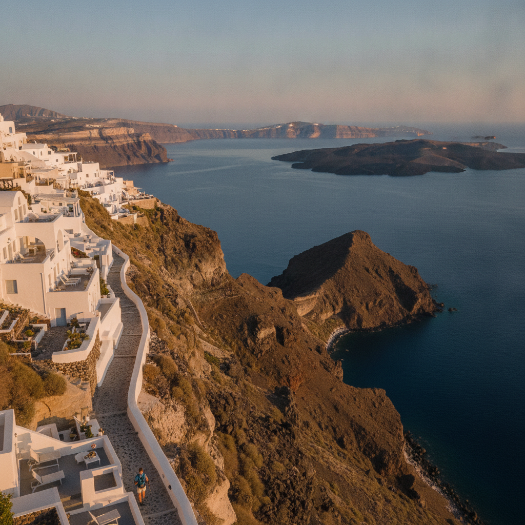
Pyrgos — the Hilltop Kastro Village at 350m
Pyrgos (the hilltop village at the geographical centre of Santorini, 350m altitude, the medieval Venetian kastro the best-preserved on the island, the concentric circular street pattern of the defensive village clearly legible from above) is accessible by bus from Fira in 20 minutes (€1.80) or by car in 12 minutes. The Monastery of Profitis Ilias (the 18th-century monastery on the summit above Pyrgos at 566m, the highest point on Santorini, the monastery church of the Prophet Elijah open to visitors daily 8am-noon and 5-8pm, the view from the monastery terrace the most complete panorama on the island — Crete visible on clear days 110km south) and the evening at Pyrgos (the least touristy sunset experience on Santorini — the Santo Wines tasting terrace visible from the village, the caldera rim sunset visible looking west, the white-painted streets of the kastro catching the same gold light as Oia with approximately 50 visitors versus Oia's 5,000) are the reasons to prioritize Pyrgos over the better-known caldera villages.
- 4
The South Coast — Vlychada and the Pumice Beach
Vlychada (the fishing harbour and beach on the south coast, 8km south of Fira by the inland road, the site of the Vlychada Marina — the main working harbour of Santorini, the fishing boats landing their catch at 5-6am, the three fish tavernas serving the freshest fish on the island at the quayside) and the Vlychada beach (the unusual pumice cliff beach — the volcanic tuff cliffs above the beach eroded by wind and rain into grotesque organic shapes, the beach itself a pale grey volcanic sand entirely different from the black Perissa sand or the red Akrotiri sand) are the south coast's twin attractions. The drive from Vlychada east to Perissa (the road passing the Vlychada marina, the Caldera View beach club at the base of the pumice cliffs, and the airport perimeter, the road running through the island's flattest agricultural section with the Assyrtiko vineyards visible on both sides) takes 15 minutes and allows a complete circuit of the southern half of the island.
- 5
Santorini Island Circuit — the Complete Drive
The complete Santorini island circuit by car (the 25km circuit of the main island from Fira clockwise through Kamari, Perissa, Vlychada, Akrotiri, the lighthouse, Emporeio, Megalochori, Pyrgos, and return to Fira, allowing stops at 3-4 locations, the circuit taking 3-4 hours with stops) provides the spatial understanding that the caldera-rim-focused standard visit completely misses: the eastern coast (the beach resort strip at Kamari and Perissa, the Mesa Vouno ridge visible above, the island's flat agricultural eastern section), the southern peninsula (the lighthouse at the southernmost point, the caldera entrance between Akrotiri and Aspronisi island visible at sea level for the first time), and the inland plateau (the fava bean and cherry tomato fields, the basket-trained Assyrtiko vines, the geological reality of the island as the surviving eastern wall of a volcanic crater).
- 6
Donkey Welfare and the Santorini Tourism Ethics
The Santorini donkeys (the animals used to carry tourists and luggage up and down the 588 steps of the Fira cliff from the Old Port since the cable car replaced the donkeys as the primary means of ascent in 1979, the donkeys still operating as a tourist ride for approximately 200,000 visitors per year, the animals requiring to carry passengers weighing up to 100kg up a 220m gradient in summer heat of 35-40 degrees Celsius, the practice banned for EU nationals by a 2018 EU guideline but not enforced in Greece, the donkeys resting in the narrow stone shelter at the top of the steps visible from the cable car station) represent the most visible animal welfare controversy in Greek island tourism. The alternative (the cable car, the 588 steps on foot in 35 minutes descending and 50 minutes ascending, the step path clearly marked and in good condition) is the responsible choice; the Santorini animal rescue organizations (the Santorini Animal Welfare Association, santorinianimals.com) provide the specific context for visitors wanting to understand the issue before deciding.