Tucson: Mount Lemmon, Tombstone, Colossal Cave, the Border at Nogales, Bisbee, and the Desert Monsoon
Tucson: Mount Lemmon (2,791m Santa Catalinas 40km northeast, Catalina Highway 29km CCC built 1933-1950 five life zones desert to spruce-fir equivalent Mexico to Canada, southernmost ski area continental US 5 runs, Summerhaven 2,640m 11-14C cooler, Bigelow Observatory UA Catalina Sky Survey 8,000 near-Earth objects 20 comets since 1998), Tombstone (80km SE, Gunfight OK Corral October 26 1881 30 seconds 30 shots 3 killed, Wyatt Earp born 1848 died 1929 LA, Doc Holliday 1851-1887 tuberculosis, silver mining Ed Schieffelin 1877 USD 2,000/ton peak pop 10,000 1881 most saloons brothels per capita American West), Colossal Cave (40km SE 1934, dry cave 2.4km tour, Sam Bass outlaw hideout USD 62K gold legend, Rincon Mountains 165km trails 2,641m Mica Mountain, Santa Ritas 2,885m Mount Wrightson best US birding Elegant Trogon Mexican hummingbirds), border (Nogales twin cities AZ 20K and Sonora 220K, I-19 only US interstate in kilometers, Mariposa port USD 30B+ produce and manufactured goods largest commercial Western Hemisphere, Tumacacori NHP mission ruins, Tubac Presidio 1752 Arizona first European settlement 100+ galleries, Santa Cruz River restored 4km downtown flow), Bisbee (130km SE largest Arizona city 1910 pop 25,000 now 5,200, Copper Queen Mine 1877-1975 USD 6.1B 8 billion lbs copper, Lavender Pit 270m deep named Harrison Lavender, July 12 1917 deportation 1,286 Wobblies to New Mexico desert worst US civil liberties violation labor history), monsoon (310+ days sunshine sunniest US city, 40C+ June-August, monsoon July 4 to September 15 60-70% rainfall, creosote petrichor actinobacteria most welcome smell, haboob 1,000m dust wall 100km wide, Gila monster only venomous lizard US, jaguar documented crossing from Sonora 1990s, 100 reptile 60 mammal 350 bird species most biodiverse desert world).
- 1
Mount Lemmon and the Santa Catalina Sky Islands
Mount Lemmon (the summit of the Santa Catalina Mountains, at 2,791 m above sea level, 40 km northeast of downtown Tucson, accessible via the Catalina Highway -- also known as the Sky Island Scenic Byway): the sky island mountain that rises from the Sonoran Desert at 728 m through five distinct life zones (Lower Sonoran, Upper Sonoran, Transition, Canadian, and Hudsonian) in 40 km of driving -- the equivalent of driving from Mexico to Canada in biological terms. The Catalina Highway (29 km of paved switchback road from the base at Tanque Verde Road to the summit, built by the Civilian Conservation Corps between 1933 and 1950): the most biologically diverse drive of comparable length in the United States, ascending through saguaro and palo verde forest, through oak woodland, through Ponderosa pine forest, and finally into spruce-fir forest at the summit -- encountering 5,000 plant species along the way. Mount Lemmon Ski Valley (at 10,800 feet elevation on the south face of Mount Lemmon, the southernmost ski area in the continental United States): the small ski area with 5 runs and a single chairlift, operating when snowfall permits (typically 3-6 weeks per year), accessible by the same Catalina Highway that serves summer hiking and mountain biking. The town of Summerhaven (at the summit of Mount Lemmon, 2,640 m): the small community of summer homes and the Mount Lemmon General Store, dramatically cooler than Tucson (by approximately 11-14C, making it a popular summer retreat). The Bigelow Observatory (at the Mount Lemmon summit): the University of Arizona Catalina Sky Survey telescope, which has discovered more near-Earth asteroids than any other observatory in the world -- the survey has discovered approximately 8,000 near-Earth objects and 20 comets since 1998.
- 2
Tombstone and the Gunfight at the O.K. Corral
Tombstone, Arizona (at 215 East Allen Street, Tombstone, AZ, 80 km southeast of Tucson): the most famous ghost town in the American West, known primarily for the Gunfight at the O.K. Corral (October 26, 1881, in the back lot of the O.K. Corral at 326 East Allen Street, Tombstone, lasting approximately 30 seconds, in which the Earp brothers and Doc Holliday shot it out with the Clanton-McLaury faction, killing 3 cowboys and wounding 3 others -- the most mythologized single minute in the history of the American West). The participants: Wyatt Earp (born March 19, 1848, Monmouth, Illinois; died January 13, 1929, Los Angeles), his brothers Virgil (the city marshal) and Morgan, and their friend Doc Holliday (John Henry Holliday, born August 14, 1851, Griffin, Georgia; died November 8, 1887, Glenwood Springs, Colorado, of tuberculosis) against Ike and Billy Clanton, Frank and Tom McLaury, and Billy Claiborne. The entire gunfight lasted 30 seconds; 30 shots were fired. The historical reality: the shootout was the culmination of a dispute between the law enforcement Earp faction and the ranching/rustling Clanton-McLaury faction (the Cowboys) over the control of Cochise County commerce and politics -- less a heroic law-versus-outlaw confrontation than a political power struggle in a frontier boomtown. Tombstone was a silver mining boomtown (the silver mines discovered by prospector Ed Schieffelin in 1877, who named the camp Tombstone after being warned by soldiers that all he would find in Apache country was his tombstone -- the ore assayed at USD 2,000 per ton) with a peak population of 10,000 in 1881 and the most saloons, gambling houses, and brothels per capita of any city in the American West.
- 3
Colossal Cave Mountain Park and Tucson's Geological Heritage
Colossal Cave Mountain Park (at 16721 East Old Spanish Trail, Vail, AZ, 40 km southeast of Tucson, established 1934 as a Pima County park): the historic cave and mountain park with a 2.4-km tour of the Colossal Cave (a dry cave -- meaning it is not actively growing, its stalactites and stalagmites having stopped forming thousands of years ago when the water table dropped), the La Posta Quemada Ranch, and trails in the Rincon Mountains. The cave history: Colossal Cave was used as a hideout by outlaws in the 1880s (including Sam Bass and his gang, whose legend claims a stolen USD 62,000 in gold coins is still hidden in the cave -- a claim that has motivated numerous (unsuccessful) amateur treasure hunts), and as a shelter by Tohono O'odham people for centuries before that. The geology of the Tucson Basin: Tucson sits in a basin (a structural depression formed by normal faulting in the Basin and Range Province -- the geological region of the American Southwest characterized by alternating mountain ranges and basins created by crustal extension beginning approximately 30 million years ago) with five mountain ranges rising above it. The Rincon Mountains (the eastern mountain range of Tucson, reaching Mica Mountain at 2,641 m): the easternmost unit of Saguaro National Park, with 165 km of trails from the saguaro desert floor to the pine-fir summit. The Santa Rita Mountains (70 km south of Tucson, reaching 2,885 m at Mount Wrightson): the most biodiverse sky island range in Arizona, with a birding reputation that attracts ornithologists from worldwide -- the Santa Ritas and the adjacent Huachuca Mountains are the best places in the United States to see Elegant Trogon, Sulphur-bellied Flycatcher, and five species of Mexican hummingbirds.
- 4
The Border - Tucson, Nogales, and the US-Mexico Crossing
Nogales (the twin cities of Nogales, Arizona (population 20,000) and Nogales, Sonora, Mexico (population 220,000), separated by the US-Mexico border fence at 48 km south of Tucson via I-19, the only interstate highway in the United States signed in kilometers): the most intimate and closely integrated US-Mexico border crossing in the American Southwest, with Nogales, Sonora offering the most accessible authentic Mexican market experience (the mercado along Obregon Avenue and the surrounding streets of the downtown) within an hour of a major American city. The border wall: the current border fence in Nogales is a 7-meter-high steel barrier completed in stages from the 1990s through the 2010s, separating two urban communities that share the same geography, many families (divided by the border), and the same economic fate. The Mariposa land port of entry (the busiest commercial vehicle crossing in the Western Hemisphere by cargo tonnage): the crossing through which USD 30B+ of produce and manufactured goods flow annually between the United States and Mexico, including the majority of the fresh produce consumed in the US from October to June (the winter vegetable production of the Sonora coastal plain and Sinaloa). The Tumacacori-Tubac corridor (I-19 between Tucson and Nogales): the mission ruins at Tumacacori National Historical Park (see Route 1), and the artisan colony of Tubac (established by the Spanish as the Presidio San Ignacio de Tubac in 1752 -- Arizona's first European settlement, now a village of approximately 1,400 people with 100+ galleries and studios, the largest art community in rural Arizona). The Santa Cruz River: the river that flows through Nogales and Tucson (northward, one of the few northward-flowing rivers in North America) and along the I-19 corridor has run dry in the Tucson stretch for most of the 20th century due to groundwater pumping, but environmental restoration programs have restored flow to a 4-km stretch through downtown Tucson.
- 5
Bisbee, the Copper King, and the Arizona Mining Legacy
Bisbee, Arizona (at 7 Brewery Avenue, Bisbee, AZ, 130 km southeast of Tucson on AZ-80): the former copper mining boomtown turned arts colony in the Mule Mountains of Cochise County, with a population that peaked at 25,000 (1910, when Bisbee was the largest city in Arizona -- larger than Phoenix or Tucson) and now stands at approximately 5,200, making it one of the most dramatic population-decline stories of any American city. The Copper Queen Mine (at 478 Dart Road, Bisbee, operated by the Phelps Dodge Corporation from 1877 to 1975, producing USD 6.1B worth of copper at modern prices -- approximately 8 billion pounds of copper, plus gold, silver, and lead): the single most productive copper mine in the history of Arizona, which produced more copper than any other mine in the world during the period 1880-1920. The Lavender Pit (the open-pit copper mine at the edge of downtown Bisbee, 270 m deep, 1.3 km long, 600 m wide, excavated 1950-1974): the enormous pit visible from the street that produces the most dramatic industrial landscape in Arizona, named for Harrison Lavender, the Phelps Dodge mine manager who proposed the open-pit expansion. The deportation of 1917: on July 12, 1917 (during World War I), Cochise County Sheriff Harry Wheeler deputized 2,000 Bisbee citizens to arrest 1,286 striking miners (members of the Industrial Workers of the World -- the Wobblies -- who had struck for better wages and safety conditions), load them onto cattle cars, and deport them to the New Mexico desert 270 km away without food or water -- an event still cited as one of the most egregious violations of civil liberties in American labor history. The Bisbee Mining and Historical Museum (at 5 Copper Queen Plaza): the Smithsonian-affiliated museum in the former Phelps Dodge general offices.
- 6
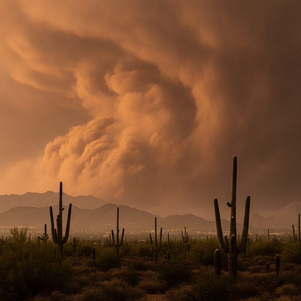
Tucson Weather, Wildlife, and the Desert Monsoon Experience
The Sonoran Desert climate: Tucson has one of the most distinctive and dramatic climates of any major American city -- 310+ days of sunshine per year (making it the sunniest city in the United States, ahead of Phoenix and Las Vegas), summer temperatures regularly exceeding 40C (104F) from June through August, a dry foresummer drought in May-June that is the most stressful period for desert wildlife, and then the dramatic reversal of the North American Monsoon (July 4 to September 15, delivering 60-70% of annual rainfall in afternoon and evening thunderstorms). The summer monsoon: the monsoon arrives with startling regularity around July 4 each year, triggered by the shift of upper-level high pressure to the north that draws moisture from the Gulf of Mexico and Gulf of California into Arizona. The first monsoon storms transform the desert -- dry creek beds (washes) fill with rushing brown water within minutes of a storm beginning 50 km away; the creosote bush (Larrea tridentata) releases the distinctive petrichor smell (3-methyl-2-(2-methylpropyl)-2-cyclopenten-1-one, released by actinobacteria in the soil activated by rainwater) that many Tucsonans describe as the most distinctive and welcome smell in the world. The haboob (the Arabic word for the dust storms that precede monsoon thunderstorms in the Sonoran Desert): walls of brown dust 1,000 m high and 100 km wide that roll across the desert floor ahead of the cooler air of an approaching storm, reducing visibility to zero in minutes and coating every outdoor surface in fine red-brown Sonoran dust. The Tucson Wildlife: the Sonoran Desert is the most biologically diverse desert in the world, with 100 species of reptiles, 60 species of mammals, and 350 species of birds in the Tucson area -- including the Gila monster (Heloderma suspectum, the only venomous lizard native to the United States), the Mexican spotted owl (Strix occidentalis lucida), and the jaguar (Panthera onca, which has been documented crossing from Sonora into the Tucson-area sky islands since the 1990s).