Windhoek: Walvis Bay Flamingos, Sossusvlei Geology, Twyfelfontein UNESCO Rock Engravings, Caprivi Strip, and Photography
Namibia landscapes: the Walvis Bay lagoon flamingo colony, Sossusvlei dune geology and photography guide, Twyfelfontein San rock engravings UNESCO site, the Caprivi Strip and Botswana border area, and the complete Namibia landscape photography guide.
- 1
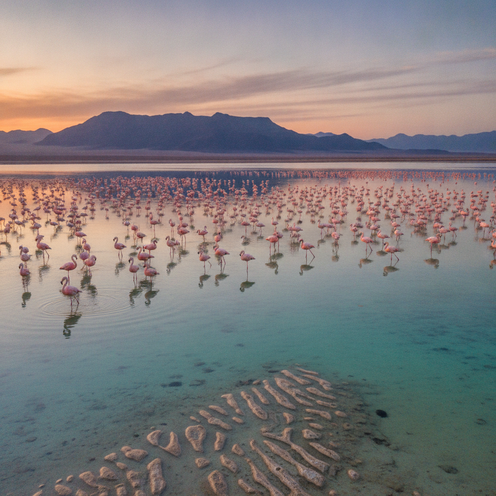
Walvis Bay - The Lagoon, Flamingos, and the Atlantic Oysters
Walvis Bay: the primary port and commercial harbor of Namibia, approximately 360 km west of Windhoek at the Atlantic coast (adjacent to Swakopmund). The Walvis Bay Lagoon (a Ramsar Wetland of International Importance): the most significant coastal wetland in southern Africa, supporting approximately 100,000-150,000 birds at peak season including 50,000-80,000 greater and lesser flamingos (the largest flamingo congregation in the southern hemisphere). The Walvis Bay oyster industry: the cold Benguela Current upwelling creates nutrient-rich waters that support one of the finest oyster cultivation operations in Africa; the Walvis Bay oysters are exported internationally. The Pelican Bay (the area of the lagoon where the brown pelicans congregate): the pelicans are so accustomed to the fishing boats that they board the boats to feed from the fish catch. The Sandwich Harbour (approximately 50 km south of Walvis Bay): a restricted lagoon area where the Namib Desert sand dunes meet the Atlantic Ocean, accessible by 4x4 only.
- 2
The Sossusvlei Red Dunes in Depth - Geology and Photography
The Sossusvlei dune field geology. The sand of the Sossusvlei dunes originated from sediment deposited by the Orange River and transported by coastal winds and the Benguela Current. The sand has been continuously reworked for approximately 5 million years. The red color: iron oxide (rust) coating the sand grains that have been exposed to the oxidizing atmosphere over millions of years; the older the dune, the redder the sand (the Sossusvlei dunes are ancient). The Tsauchab River (the ephemeral river that created the Sossusvlei clay pans): the river floods approximately every 5-10 years, creating temporary lakes at the base of the dunes. The Deadvlei (the white clay pan surrounded by dead camelhorn acacia trees): the trees died approximately 700-900 years ago when the river changed course; the arid climate has preserved the dead trees without decomposition. Photography at Sossusvlei: arrive before dawn to climb Dune 45 for the sunrise (the changing light on the red dunes between 5:30 and 7:30am is the most photographed moment in Namibia).
- 3
The Damaraland - Twyfelfontein Rock Engravings UNESCO Site
Damaraland: the arid, mountainous region of north-central Namibia (the Kunene and Erongo Regions), home to the Damara people (one of the indigenous Khoisan-speaking people of Namibia, with a click language). Twyfelfontein (UNESCO World Heritage Site, 2007): the most significant rock engraving (petroglyph) site in Africa, with approximately 2,500 individual rock engravings spanning a period from approximately 2,000 to 6,000 years old, made by the San people at a spring site. The engravings depict animals (giraffe, elephant, rhino, lion, ostrich) and human figures, and are believed to be related to San shamanic ritual practices. The Brandberg (the highest mountain in Namibia at 2,573 meters, in the western Damaraland): the White Lady rock painting (a famous San painting in the Tsisab Ravine of the Brandberg, depicting a human figure painted in white with a flower). The Petrified Forest (approximately 40 km west of Khorixas): fossilized tree trunks approximately 280 million years old from the Gondwana supercontinent era.
- 4
The Caprivi Strip and the Okavango Delta from Namibia
The Caprivi Strip (now officially the Zambezi Region): the unusual 450-km-long narrow projection of Namibian territory that extends eastward to the borders with Zambia, Botswana, and Zimbabwe. The Caprivi Strip was created by the 1890 Heligoland-Zanzibar Treaty between Germany and Britain, granting Germany access to the Zambezi River (the German colonial administration wanted a route to transport troops eastward to German East Africa). Katima Mulilo: the main town of the Caprivi Strip. Bwabwata National Park, the Mudumu National Park, and the Mamili National Park (the Namibian equivalent of the Okavango Delta ecosystems): the Linyanti and Kwando River systems support large elephant herds, hippo, crocodile, and the African wild dog. The Caprivi area provides access to the Okavango Delta of Botswana (approximately 100 km south) and to Chobe National Park (approximately 70 km east in Botswana, the largest elephant population in Africa).
- 5
The Namibia Photography Guide - Landscapes, Light, and Wildlife
Namibia is one of the most photographed countries in the world for landscape photography. The primary photography subjects: Sossusvlei dunes at dawn (the changing light from deep red to gold), the Deadvlei dead trees against the white clay (the most dramatic abstract landscape in Africa), the Etosha Pan water holes at sunset (the dust clouds raised by the animals), the Cape Fur Seal colony at Cape Cross (the overwhelming abundance of wildlife), the Himba people of the Kaokoveld (with permission), and the Kolmanskop ghost town interiors. The photography logistics: the best light in Namibia is in the first 2 hours after dawn and the last 1.5 hours before sunset (the harsh midday Namib light washes out the color and detail). The Milky Way photography: the NamibRand Nature Reserve (the Dark Sky Reserve) in winter (May-August) provides the most dramatic Milky Way photography opportunities in Africa. The dust factor: the Namibian gravel roads generate significant dust that is damaging to camera equipment; carry cameras in sealed bags and clean sensors frequently.
- 6
Windhoek Four Routes Complete and Namibia Practical Summary
Windhoek four routes complete. Route 1: German colonial architecture, Herero Nama genocide, Etosha safari, Sossusvlei dunes, practical guide. Route 2: Himba, San, Skeleton Coast, Swakopmund, Fish River Canyon. Route 3: SWAPO independence, cheetah CCF, stargazing, Kolmanskop ghost town, game meat. Route 4 (this route): Walvis Bay lagoon and flamingos, Sossusvlei geology and photography, Twyfelfontein UNESCO rock engravings, the Caprivi Strip and Botswana border, photography guide. Routes 5-6 still needed. Namibia overview: area 825,000 sq km, population 2.6 million, independence 1990 from South Africa. Windhoek Hosea Kutako International Airport (IATA code WDH): direct flights from Frankfurt (Lufthansa, approximately 11 hours), Johannesburg (approximately 2 hours), Cape Town (approximately 2 hours). The Namibia tourism season: May-September (the dry, cool winter season) is the best time for Etosha game viewing and Drakensberg hiking; October-April (the wet, hot summer season) is the best for the Namibia landscape photography (green grass after rain). The Namibian dollar is pegged to the South African rand at 1:1; both currencies are accepted everywhere.