L'Uragano Katrina, il Lower Ninth Ward e la Resilienza di New Orleans
Hurricane Katrina (the Category 5 Atlantic hurricane that made landfall near Buras, Louisiana on August 29, 2005 — the most destructive and deadliest hurricane in US history, causing approximately $125 billion in property damage and killing approximately 1,836 people (the official death toll — actual deaths were likely higher), displacing approximately 400,000 New Orleans residents and reducing the city's population from approximately 485,000 before the storm to approximately 230,000 in the immediate aftermath): the catastrophic flooding of New Orleans (the storm surge that overtopped and breached the levee system protecting New Orleans — a city that sits predominantly below sea level (the average elevation of New Orleans is approximately 1.8 metres (6 feet) below sea level, the result of subsidence (the gradual sinking of the land due to compaction of the sediments and extraction of oil and groundwater) and the loss of the coastal wetlands that historically buffered the city from storm surge) — submerging approximately 80% of the city under water, with depths of up to 5 metres (15 feet) in the lowest-lying areas.
- 1
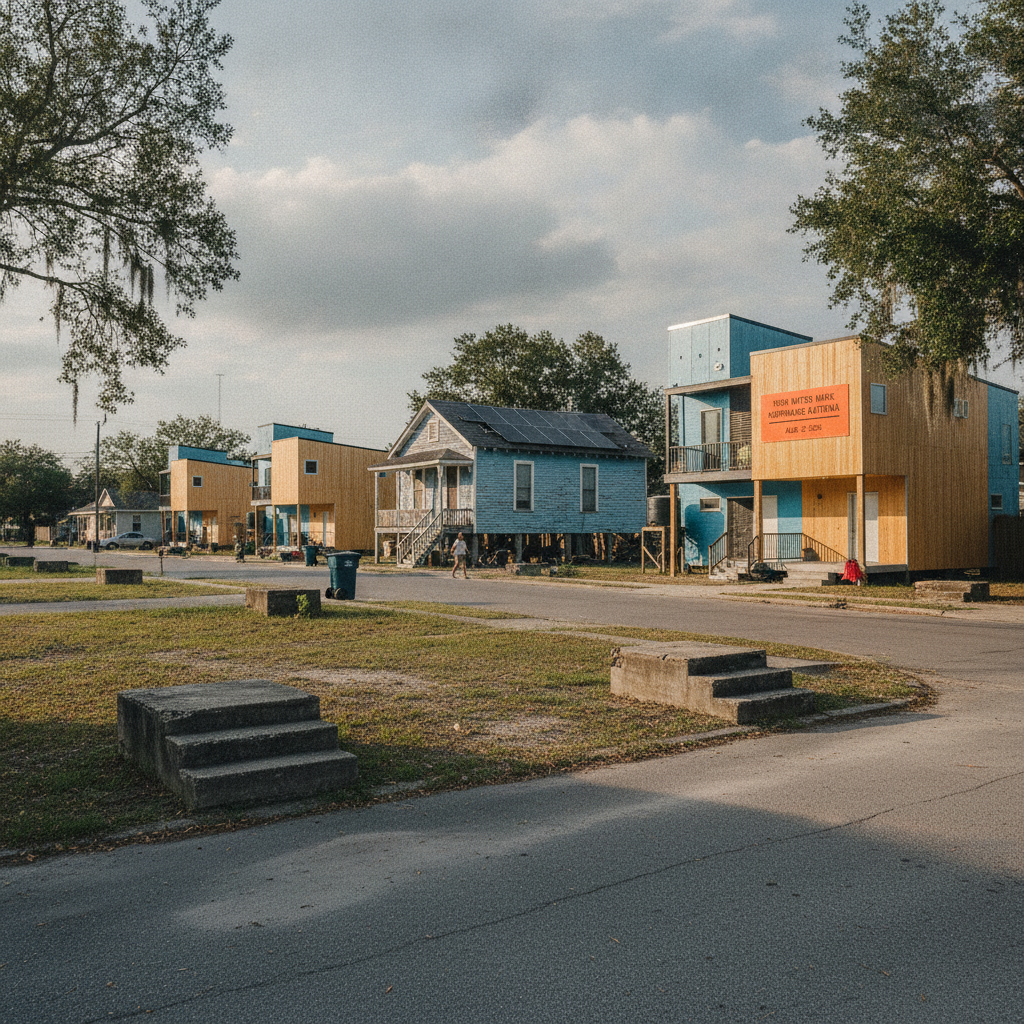
Lower Ninth Ward — Ground Zero of Katrina's Worst Damage
The Lower Ninth Ward (east of the Industrial Canal, one of New Orleans' lowest-elevation districts) bore the worst damage from Hurricane Katrina's levee failures (August 29, 2005) — the breach of the Industrial Canal levee sent a 12-foot wall of water through the neighbourhood in minutes; the Lower Ninth was 90% flooded for 3 weeks; pre-storm population of 14,000 was reduced to 3,000 by 2010; the Make It Right Foundation (Brad Pitt, 2007) built 109 sustainable houses in the neighbourhood, though many have since developed structural problems.
- 2
The Levee System and Army Corps of Engineers Failure
The Army Corps of Engineers failure (post-Katrina investigations concluded the levee failures were due to engineering design errors, not just storm intensity) is central to New Orleans' historical memory — the Lake Borgne Surge Barrier (2013, the world's largest sector gate dam, $1.1 billion) and the new pump stations (2018, 120 permanent drainage pumps) represent the post-Katrina flood protection upgrade; the Lower Ninth Ward Living Museum (1245 Deslonde Street, by appointment) documents the community's resilience and recovery.
- 3
Tulane and Charity Hospital — The Storm's Institutional Impact
Charity Hospital (1736 Gravier Street, opened 1939, the largest hospital in the South and the principal training facility for Louisiana medical residents) was damaged in Katrina and controversially closed permanently in 2005 — the decision not to reopen Charity (the primary hospital for New Orleans' uninsured poor) was the most contested healthcare policy decision of the recovery; the building (a 1939 Art Deco tower, designated historic landmark) remains vacant and is the subject of ongoing preservation debate; the new University Medical Center (2015, adjacent site) replaced it.
- 4
Fats Domino's Home — The Rock and Roll Pioneer Who Stayed
Fats Domino (Antoine Dominique Domino Jr., born 1928 Lower Ninth Ward, 'Blueberry Hill', 'Ain't That a Shame') refused to leave his Lower Ninth Ward home during Katrina — he was rescued from his rooftop by the Coast Guard; his yellow shotgun house (5515 Marais Street) survived the flood and became a national symbol of local resilience; the house was painted with the 'R&B' initials (for 'rescued by boat') by the rescue team; Domino returned to the neighbourhood in 2006 and lived there until his death in 2017.
- 5
Treme — The Black Cultural Heartland That Survived
Treme (the neighbourhood immediately downriver from the French Quarter, the oldest African American neighbourhood in the United States, where the free people of colour established themselves in the early 19th century) survived Katrina with less flooding than the Lower Ninth — the community's musical traditions (the second-line brass band parade tradition, where jazz funerals evolved into community celebrations) continued without interruption; the Backstreet Cultural Museum (1116 Henriette Delille Street) documents Mardi Gras Indians, jazz funerals, and second-line culture.
- 6
New Orleans Musicians' Village — Habitat for Humanity's Legacy
The Musicians' Village (Upper Ninth Ward, N. Rampart Street area, 2006, Habitat for Humanity with Harry Connick Jr. and Branford Marsalis) was built to house displaced New Orleans musicians — 72 homes (all built by volunteer labor) and the Ellis Marsalis Center for Music (named for the patriarch of the Marsalis jazz dynasty, free music education for children) are the village's components; the project represented the argument that New Orleans' musicians were essential infrastructure whose housing was a civic priority.